Syracuse Orange College Checks

NHL and Buffalo Sabres Checks

Cheap Syracuse Bank Checks


Golden Snowball Totals for the 2010 - 2011 Snowfall Season
Updated  5/1/2011

GSB Cities This Season Normal Average
to Date
This Time Last Season Normal
 Seasons Average
All Time Season Snowfall Record
Syracuse 179.0 111.8 106.1 121.1 192.1 inches
( 1992 - 1993 )
Rochester 127.0 99.8 89.8 100.3 161.7 inches
( 1959 - 1960 )
Binghamton 117.5 80.8 81.4 81 134.0 inches
( 1995 - 1996 )
Buffalo 111.8 96.7 74.1 97 199.4 inches
( 1976 - 1977 )
Albany 87.2 62.6 45.4 62.6 112.5 inches
( 1970 - 1971 )

Order Cheap Personal Checks Online

Deals on Bowling Balls, Bowling Bags and Bowling Accessories

Wednesday, January 30, 2008

What a Wild Day

For all that hectic weather we paid for today my snow dance only looks to have droped a single inch of snow in the Buffalo bucket. Guess I still have a few things to work out with it.

Anyways a recap of the wild day today in Buffalo.

3am the temperature rises to 53 degrees.

4am the front with a weak squall line pass through the area.

5am the winds and artic air start blasting into the area. The temperature drops to 29 degrees at the 5am report (a 24 degree temperature drop in less than 2 hours).

6am the damaging winds begin a rapid increase acorss the area. Trees and power lines begin to fall.

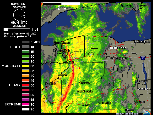
7am the winds running the full length of Lake Erie cause the water level at Buffalo harbor to rise to 11.06 feet (3.06 feet) above flood stage. This is the 2nd highest flood stage ever recorded at Buffalo harbor and while records for the highest storm surge are not kept it is very likely this storm caused the most rapid rise in the lake level. An amazing 9.5 foot rise in the lake level in just a 2 hour period. This will lead to very rare flooding along the Niagara and Buffalo Rivers. (I'll expand a bit more below).

9am while the winds appear to start subsuding the lake effect snow bursts begin to organize into more definded feeder type bands and pick up in intensity despite the strong sheering winds and partially frozen Lake Erie.

10am the snow band keep cranking and the winds again increase. Sustained winds at the Buffalo Airport peak at 54 mph with a gust of 68 mph recorded. Many school net reporting stations record gusts in the mid to high 60's, with two reporting gusts in the 70's, and a station south of Buffalo (Starpoint) recording a gust of 81mph. As many as 60,000 customers in WNY are without power.

12pm the winds keep going strong in the 40-50 mph range. The lake effect is still cranking over the Buffalo area. The NYS thruway is shutdown from Buffalo to Rochester.

2pm the winds let up a bit into the 30-40mph range but the lake snows begin to start breaking up and moving a bit south of the area.

5pm, winds are down to 25-30mph and the lake snows are largely broken apart and south of the area.

8pm the NYS thruway reopens. Conditions have improved dramitcally with only patchy areas of difficult travel.


I've got to say this is probably one of the worst winter storms I have ever seen in my 22 years living in WNY. I was really expecting the NWS to issue Blizzard Warnings for a point late this morning but as bad as it was we just didnt hit the criteria and really the worst weather only last about 5 hours. This is probably the closest thing weve seen to a real blizzard since 1977. In my opinion the only thing that really didn't make this storm that bad was the lack of snowfall. We saw a good 4-6 hour period of really only moderate lake effect that seemed severe with the winds. But we had no snowpack to be blown around. Had we had a decent snowpack on the ground before this storm, or if the lake effect been more intense things would have certainly been much worse.

Probably the most interesting aspect to this storm was the lakeshore flash flooding. Now if there is anyone who knows the last time these events happened please let me know, I know it has happened before but it's been a long time since the Buffalo River flooded the old first ward of South Buffalo and the Niagara River spilled its banks along Grand Island, Tonawanada and Fort Erie in Canada. It was amazing to see how the rapid rise in the lake level caused the Buffalo River to back up and in a way reverse ice jam sending huge amounts of water backwards upstream. This backup even sent water rushing back into the feeder creeks of the Buffalo River and lead to a quick rise of 1-2 feet. Meanwhile along the Niagara River the winds and push of the water caused a great deal of ice to be forced over the ice boom that keeps the ice in Lake Erie and out of the Niagara River where it can cause damage to the power plants near Niagara Falls. The boom held up pretty good considering the conditions but still ended up being breached in at least two spots which lead to even more ice pouring into the Niagara River. This lead to even more rare flooding along the Tonawanda River Walks and homes and Marinas on Grand Island. Due to the location of the Niagara River sucking water from Lake Erie and then quickly pulling it over the falls, the level of the river is usually very slow to change and flash flooding conditions are a rare occurance. Seeing some of the pictures of the fishing peirs (which usually are 6-10 feet above the river level) completely underwater with floating ice chunks was unreal.

Here is a chart comparing the Buffalo Harbor water level to the Toledo water level this morning. Can certainly see where all the water came to and left from.


Here is a larger view of the CHART.


Now for some photos. Takes to long to upload all of them on here so I'll just link them.

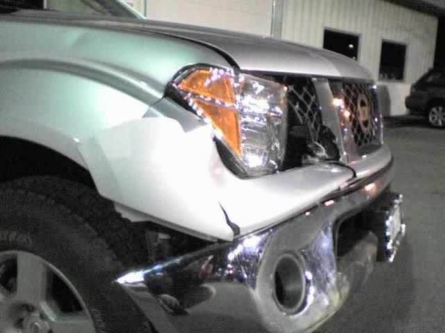
Got to feel bad for this guy.

This car didn't make out much better either.


Flooding in Grand Island, so much for that nice river front property.

Flooding in South Buffalo's old First Ward came quickly flooding the streets and basements.

The riverwalk along the Erie Canal can't even be seen after the rise from Lake Erie poured into the canal.


A few of my damage pictures...

A construction trailer flipped on its side.

Two trees down on the same house. Luckily the car was spared!

Poor driving conditions!

ZERO visibility!


Ok enough about the storm. Things look to get interesting again in the next day or two with winter storm watches up. Snow/Sleet/Freezing Rain, a nice mix of everything is on tap!

HOLD ONTO YOU HATS TODAY!

Another powerful wind storm is raking across upstate NY today. Much like the event that hit us three weeks ago on January 9th. The inital storm front this time was not as powerful as three weeks ago but the winds behind the frontal passage are certainly packing a little more of a punch. The winds right now seem to be letting up a little in the Buffalo area after two straight hourly reports from the airport of sustained winds at 53mph with gusts to 64 mph.

Quite a bit of damage around the area, lots of downed limbs, trees, power lines, traffic lights, semis blown over on the thruway. The airport is still opened but almost everything leaving town is canceled or delayed for a lenghty time. Almost all of the schools in the WNY area are closed. Somewhere in the neighborhood of 54,000 plus without power this morning. Lake Effect pockets are giving quick shots of white outs. One of the most interesting things is the flash flooding that is taking place along the Buffalo and Niagara Rivers. The ice that was being held in the lake is being forced over the boom with quite a bit of force and combined with the extra push of water from the lake the Niagara River is creating ice jams along the river. Something I can never remember happening before. Really curious as to what shape the ice boom is in right now after this storm.

More to come with pictures later! Stay safe today everyone!

Tuesday, January 29, 2008

Buffalo Snow Dance & Blizzard Week in Buffalo

BREAKING NEWS!!!!!

The Buffalo snow dance has been done!

Dance one resulted in 60 mph winds, thunderstorms, and power outages...

Dance two lead to a good amount of snow in Buffalo helping to maintain third place in the standings...

Dance three... we will see what happens....


While a video may or may not exist of parts of the Buffalo snow dance I will confirm the ritual took place around the 9:00pm hour Monday night. Unfortunately due to an excessive amount of pre ritual beverages my ceremony turned from sacrificing a 6 foot snow man (blowing his as... "behind" up) to burning a 2 foot replica of him to the ground.Regardless those in Buffalo can be certain we are due for some INTERESTING weather now this week.

ON another note Monday marked the 31st anniversary of the great blizzard of 1977. I hate to make those plugs like Patrick does but this is certainly an interesting you tube video to check out. If you like the video be sure to check out www.whitedeath.com where you can purchase the full length DVD and the associated book by Erno Rossi. I'm not a big book person but his account of the storm is simply AWESOME! Check it out!

Sunday, January 27, 2008

Opinions Still Needed

Charlie English is still looking for more of your thoughts and feelings about the snow we receive in the Great state of New York. Take a few minutes and fill him in on how you think the snow we get is good or bad. You can leave your comments here at http://goldensnowball.com/2008/01/snow-lovers-and-haters-opinions-needed.html

Thanks everyone!

Friday, January 25, 2008

Rochester's Making a Move and The Snow Dance

Rochester continues their march up the snow hill trying to be king and right now they are only 3.6 inches away from throwing Syracuse off the top of the hill. Looking at last years totals for this time in the season has me a little worried as a Syracusan and here's why.

Last season most of us got off to a slow start but Rochester was really slow and was trailing Syracuse by 15 inches at this time last year and fell even further behind before they started a come back. Although we ended up blowing them away by the time the season ended they made a pretty good charge for awhile and I think it was about mid February when they started the charge. That's why Syracuse might want to be a little worried this year. They have already started to make their move and it's way earlier than they did last season. We'll have to wait and see how serious they are about winning the trophy.

Don't count Buffalo out of this yet either. Although the lake has been freezing over pretty rapidly the last week or so (see maps below) there is still enough open water to keep the lake machine running. Plus, my guess is that he General probably has some kind of destroyer on order to cruise through the lake and break all of the ice up if it's needed. Ya have to keep an eye on the General, he's a tricky kind of guy ;)

Is it time for the famous snow dance to take place??? You bet it is and it will be taken place in the very near future and this season the General from Buffalo is going to also do one or two, three. I believe this will be his third one of the season. No make that his second one. The first one was kind of an experiment for him and his dance ended up almost producing a hurricane. So we'll consider that one some kind of wind dance. Yup, remember that windy day a few weeks back? Enough said ; ) Anyways the General called me out on a snow dance and with the contest being so close right now I figured I better do something to keep the trophy here in DaCuse another season so it will be happening maybe come Tuesday. At least that is what I told the General anyways, Shhhhhhh. Have a great day everyone.

Thursday, January 24, 2008

Syracuse Falls to Last Place

No, not for the seasonal snow totals but for the month. Yup, for the month of January Syracuse is in last place for snow totals which I find pretty interesting and if they don't get something going pretty soon they may also find themselves out of the lead for the Golden Snowball contest.

Here are the stats for the month of January and looking at them my guess is that Lake Erie is still alive and kicking. January snowfall so far:

Buffalo - 13.9
Rochester - 11.9
Albany - 7.2
Binghamton - 6.6
Syracuse - 4.2

After posting I was just reading around and noticed that Jim Teske a meteorologist from the WSYR Channel 9 news weather blog has some stats on Syracuse's January all time snow stats which is worth checking out at http://community.9wsyr.com/blogs/weather_discussion/archive/2008/01/24/2426474.aspx .

A visitor to the GSB site, Dick Stinneford from Virginia who was born in Buffalo and lived in Olean has sent a great map from the NOAA site of the icing on the lakes including lake Erie which shows what parts of the lake have frozen over already and how much is left unfrozen so far. Dick also pointed out what a difference a week makes which you can see by looking at the first map which is the most recent, from today and the second map of the Great Lakes which was from Jan 17th. Thanks for taking the time Dick, it's deeply appreciated ;) A question for the pros. Are the color codes the thickness of the ice ex. orange would be a thickness of 7 to 8 inch thickness and what does the 10 mean? EX; 7-8'/10.

Just Click Image to Enlarge
Jan 24th NOAA Lake Ice

January 17th Ice on Lakes


My guess is that Syracuse will start getting dumped on sometime soon. Here is why. I shoveled my tail off during the month of December while all of my kids were off at college. All 3 kids are back to college now after the Christmas break as of yesterday which is when my daughter went back to Suny Oswego. Number of times they had to shovel my driveway while on Christmas break? Zero!!! To sum this rant up there has been no snow to shovel when the kids were around but when they aren't around to help you can bet it will start snowing again. I think my daughters boyfriend Justin who also attends Oswego was a little surprised when I told him that as they drove back yesterday they will be entering a different world than they left behind here in snowless Syracuse and where he is from which is Norwich. Other than the winds which they are trying to get use to if they are lucky they will get to see the snow bands coming right at them. Their building has an awesome view of the lake from the top floor and they should be able to see the lake effect coming right at them.

Syracuse better watch their back because Rochester has slowly been inching their way towards the king of the snow hill top spot. Currently they are only 5.5 inches away from taking over the snow hill. I didn't think I would be saying this but don't count Buffalo out yet either. They have been picking up the pace the last several days and are only about a foot out of the lead. Until that lake freezes over we all better be worried about them. Binghamton and Albany aren't a threat yet but if the Nor Easter's continue they could mount a push to the top. In other words it's still a good race and any of the GSB cities could pull off an upset over DaCuse this year.


Have a great day all!

Monday, January 21, 2008

Reb up The Engines and Head North

First off, Congratulations to the Syracuse Orange Women's Basketball Team on breaking into the top 25 in the AP Rankings coming in at #24. Well deserved for your hard work and keep it going!!! http://sports.espn.go.com/ncw/rankings I listened to most of the UConn game on the radio and man that was just as exciting as any men's basketball game.

OK, About a week ago I almost typed that a couple of the Golden Snowball cities are within reach of catching some of the snow totals from up North like Oswego and Fulton. Then reality set in and I decided to wait another 2 months before I type something like that. Well the north has finally turned on their lake effect machine and it's still running. More than enough to get the snowmobilers hitting the trails once their groomed and it's cold enough so the snow should be sticking around this time.

Here are some stats that were posted by ZR800 in the forum this morning and more has fallen since then and look at the snow rates. It was and could still be in certain places falling at 2 to 3 inches an hour:

...OSWEGO COUNTY...
FULTON 37.0 422 AM 1/21 18" LAST 9 HOURS. ENDED
OSWEGO 30.0 600 AM 1/21 15" LAST 7 HRS...CITY.
MEXICO 26.0 300 AM 1/21 7" LAST 2 HOURS

I took a look at the Northern Chateau cam online a couple of hours ago at http://www.northernchateau.com/webcam.html and the measurement was showing just under a foot of snow which is where it was a couple of days ago. Now it's at the 1 1/2 foot mark which means they are most likely getting 2 to 3 inches an hour right now and Tina from the forum who lives up that way said it was something like 13 below this morning there so that snow won't be going anywhere soon.

In Fulton more than snow is coming down. Unfortunately the DPW garage came down also. Well the roof did anyways and looking at the pictures it looks like the whole building might have to come down. Check out the story and pictures at http://blog.syracuse.com/news/2008/01/local_news_64.html . I guess if there is any good news to come out of it it's that nobody was hurt and the plows were out of the building at the time which is kind of obvious to me that they would be. It sounds like the dump trucks and some other equipment were in there though so for those of you in the Fulton area it looks like trash pickup will come a week late. Fulton is also under an emergency right now until they get things cleaned up. Maybe Jeff Brown, our DPW head man will send some plows their way to pitch in????

For those of us in the GSB cities we can only look at the snow (depressing) in other cities right now which is pretty pitiful in my opinion. I was hoping that the band of snow off the lake would have come a little further south to Syracuse but like last year when all the heavy stuff hit the north it just wouldn't quite reach us. Anyways you can check out the Tug Hill area using the cam mentioned above. My daughter will be heading back to Suny Oswego come Wednesday as her Christmas break ends and you can check out what she has to look forward to by going to the Suny Oswego cam at http://www.oswego.edu/webcam/index.html . Have a Great Week All!

Thursday, January 17, 2008

Wow, The Snow Race is Close

Just a heads up on the weather and also the comments received so far about how we all feel about snow have been great. Thanks and plenty more views are wanted so keep leaving your comments about how snow effects you at http://goldensnowball.com/2008/01/snow-lovers-and-haters-opinions-needed.html .

It looks like another near hit storm that will most likely miss or at the most just graze most of the Golden Snowball cities. The storm that is coming up the coast and is just about to reach us all is pretty much doing the same as the last storm is. Staying to far East to give us any decent amounts of snowfall. I'm going to say it again.

Buffalo watch your back because you are soooo close to dropping to last place. I think my bias is starting to show a little huh. I just think it will be fun to see either Binghamton and Albany ahead of any of the big 3 and be at the bottom. Even if it is Syracuse or Rochester but right now it's Buffalo trying to fend off the last place spot.

What is pretty cool in my opinion is that although Buffalo is close to falling to last place they aren't that far out of first place as far as snow totals go for the contest. Just think about it. There is only about 22 inches separating last place Binghamton (that was fun to say) and first place Syracuse this year. We all know by now that change in the winds during a storm or lake effect snow one direction or the other can even things up pretty quickly. Rochester has been slowly building their snow pile numbers up and are sneaking Right up to Syracuse now less than 8 inches away from taking the lead over. My point is that this seasons snow contest is a lot closer than it might seem by looking at the stats.

Another thing, is it time for a snow dance. Looking at last years numbers that snowy December we had this season to give us all an above normal amount of snow has slowly slid away and things have pretty much caught up. I think we should give it another week and see how the lake effect snow plays out with the Arctic air moving in before we have to revert to the snow dance, using reverse Psychology or asking NYCO to put the Snow God on warning that it might end up back in the closet.

Enough said and please keep your responses coming about your feeling about out snow in the post I made the other day below. They are much appreciated and really interesting to read. For what it's worth I'm forecasting that Buffalo drops at least one spot by tomorrow evening with a real possibility of dropping all the way to the bottom. Have a great evening all and Go Binghamton and Albany!!!!

Tuesday, January 15, 2008

Snow Lovers and Haters Opinions Needed

Here's where your help and input is needed and deeply appreciated. Since yesterday I have been doing an email exchange with Charlie English who is a journalist from London and who works for the Guardian ( http://www.guardian.co.uk/ ) is working on a book about snow and its effect on people? Charlie visited family in CNY in February of 2006 and really liked it and wants to know how we all feel about the snow we receive each year. I'm hoping for a good response from all of you New Yorkers who visit the Golden Snowball website so that Charlie can get a good feel as what kind of effect it has on all of us. Obviously some of us hate the snow and some of us love it.

Quite often the Golden Snowball website gets some interesting emails from people all over the state and even the entire country either asking about the weather or contest or voicing an opinion about the snowfall that New York state receives. Only once in awhile do we get emails from other countries asking about the snow and the Golden Snowball contest and in my opinion it's pretty cool when it happens.

Below are a few questions that Charlie English is interested in for any of you willing to help out. You can just post your answers and feelings by clicking on the comment link and remember they get moderated before they post so don't worry if it doesn't show up right away. You don't have to sign up to post a comment here, you can just check either the anonymous spot or the nickname box and type a name in there. You don't have to use your real name but PLEASE let us know from what part of New York you are from and thanks for your responses.

Some Questions;

One of the questions Charlie has is about the Psychological effect the snow has on you. Does it put you in a better mood when it's snowing out or does the snow get you down a little bit or a lot.

Does it have an affect on our sense of humor during the snow season? How about your family or friends?

What helps you to get by during the snowy months? Playing in it or just trying to avoid it completely.

I know that there comes a point for most of us other than the sledders and skiers where enough is enough. When is it enough for you? In other words come the first snowfall is enough already or can you deal with it much longer.

What do you like about our winters or for a couple of you what don't you like about the snow? Yeah I know it's more than a couple who don't like the snow.

In summary I think what Charlie is looking for is pretty much your general opinion and how you feel about all the snow we get in New York. whether it's a good or a bad opinion, mood swings and so on. Just chime away and your answers are appreciated. Make sure to add where you are from though whether it's the Tug Hill area up north, Buffalo, Syracuse, Utica or wherever and thanks for taking the time. Have a great day all!

Monday, January 14, 2008

Binghamton Can Show Their Faces Again

I figured I would do an evening update because Binghamton has finally dug their way out from the bottom and we'll see if it will last. Hopefully Mike and the others will come back and play now :p The latest update shows Binghamton edging their way out of last place by only a tenth of an inch. The question is can they stay out of last place for awhile???

Buffalo is really, really, REALLY skating on thin ice this season and right now they are only 2 inches away from sledding to the bottom in the GSB contest. Even if they tie Albany they are still going straight to the bottom :) Only because we list them alphabetically during a tie. Well that plus it will be just a lot of fun to see Buffalo on the bottom for a change and especially this far into the snow season.

Snow is in the forecast for a good part of the week so hopefully there will be a lot more updates to come. Something could be trying to whip up for the end of the week and we'll post more if it all comes together. Hopefully one of the experts will jump in and keep us updated. I won't even get into my prediction I made for the SU game Sunday. It's best just left alone. Have a super night all!

Sunday, January 13, 2008

A Little Snow and SU Women's Basketball

From reading around it looks like a couple of inches here and there are in the forecast for most of the Golden Snowball cities. A storm that will be coming up the coast looks like it will stay far enough to the east to miss CNY. It could get interesting though between Binghamton, Albany and Buffalo with the storm that will be moving up some time soon. Right now from what I am reading it is expected to stay to the eastern part of New York but if Albany can grab some snow from it they could skate into 3rd place.

Another scenario is if the storm can hang north east long enough to give Binghamton and Albany both a little bit of snow Buffalo could find itself in dead last. Go Bingo, Go Albany :) My guess is if that happened the General would be on a plane out of Buffalo by Tuesday because of embarrassment. I don't see it happening but it is a possibility. OK, the General will be heading out on Tuesday whether they are in last or not but the embarrassment part sounded good :) Enough about weather!

Go SU basketball! I'm talking the SU women's team who is rocking this season. Another big win last night over South Florida moves their record up to 14 - 2 and 2-1 in the Big East. Way to go ladies and keep on rocking!!! They have the game of the season coming up Tuesday night against UConn who is ranked #1 in the country right now. Start sending the vibes to the SU women's basketball team so they can pull off the big upset of the season by beating the Huskies Tuesday night. Better yet it's a home game so get out there and support them. I'm as guilty as the rest of Syracuse having only gone to a couple of women's basketball games in my life but it's better late than never to support their hard work. Unfortunately I have a prior commitment because I would rather be going to watch SU beat UConn and I can feel it's going to happen. Who knows, maybe I will end up being able to watch the game. To Time Warner!!! START SHOWING THE WOMEN'S GAMES ON TV!!!!

It will be interesting to see if they can break the top 25 this week after last nights win over S. Florida. They had a loss to Pitt during the week but Pittsburgh was ranked 26 and SU 27 last week so hopefully the committee ranks them both in the top 25. Good Luck ladies come Tuesday night!

The men's basketball team plays West Virgina in about half an hour and it should be a good game. Lets hope that they can turn around that loss from the other night and get a good road win today. They didn't seem to have the running game going the last game and got beat up on the boards. If they can control the boards today and get the fast breaks going they shouldn't have a problem. If they can't control the boards look for a close game. Su by 18, 83 - 65 the Orange! Have a great day everyone!

Friday, January 11, 2008

Blame the Weather on a Little Girl Not the Meteorologists

Is the little girl to blame for the wacky weather? Hopefully that little burst at least gave our Fort Drum soldiers a little taste of home.


La Nina which from what I have read so far means "Little Girl" in Spanish and it seems that we are seeing the little girl cast her spells in many parts of the world. Sully who is a visitor to the Golden Snowball website has been giving us some great informative information about what could be going on right now weather wise. From what Sully says and trust me when I say I could be mis-interpreting it because it's pretty technical stuff, is that come the end of this month it will be an official La Nina and most likely a labeled as a pretty strong La Nina or at the very least a moderate one. I'm not going to go rant on about it because I'm still a little clueless (go figure huh) and I'm still Reading up on it. From what I have read it happens because of the water temperatures get colder in the 3.4 region, I think. One thing I did read is that the waters around Australia were colder than normal which may be playing a little havoc as to what normally occurs during a La Nina. Hopefully Sully will stop by when he is feeling a little better and clear up anything I have wrong. Most likely all of it :) Below are some of Sully's responses that he posted at GSB and once again a big thanks Sully for the great information and Sully has a great informative weather blog at http://www.wunderground.com/blog/sullivanweather/ :)

Part of a Conversation about the Warm Weather and La Nina (Little Girl);


SULLY: To have two consecutive years of all-time record breaking warmth is quite unusual. Then again, when one has such a powerhouse Pacific storm system flooding the country with mild Pacific air on the heels of a record breaking area of high pressure (a few records for highest atmospheric pressure were broken over the southeast last week) the return flow of air between these two very large strong synoptic features will most certainly be able to tap the sub-tropics/tropics. The Pacific system's source air also came from near 30°N, which is the top of the 'horseshoe' of warmer than normal SST's that typically exists during La Nina winters. If you notice many of the all-time record highs across the Northeast for January occurred in 1950 (Strong La Nina) and 1967 (cold neutral - ONI -0.4 close to the 5 month consecutive -0.5 or lower to meet La Nina criteria as the next 3 months dipped into weak La Nina conditions -0.5,-0.6,-0.5). Those years also had major severe weather outbreaks very similar to those experienced over the previous two days.With that being said La Nina is also known for its wild temperature fluctuations and this will show itself later this month as a rather significant arctic outbreak should push its way over from Siberia. There's already indications of this arctic air becoming displaced as there's ridging beginning to develop, and more importantly, retrograde over eastern Asia/western Pacific. Usually when this event begins to take place arctic air is about 7-10 days away for the western hemisphere. AO/NAO variables at that time will determine how far south this arctic air will push. Current ensemble means have neutral conditions in the day 7-14 period which would have this airmass evac over the Canadian Martimes/northern New England, but this is still one to two weeks away and much can change between now and then. As it is the AO has been wildly variable for the last 6 months so I doubt a neutral AO will prevail over that entire time frame so somewhere over the northern tier of the US will get clipped by this airmass.
1/8/08 4:45 PM

Patrick said...
Sully, thanks for the great detailed explanation as to what's going on. WeatherT from the forum also mentioned something about some pretty cold air getting ready to most likely over take the NE. Out of curiosity is the current La Nina considered weak or strong???

Sully said...
Patrick, The current La Nina is actually considered 'moderate'. The CPC rates La Nina on the ONI index which is a measure of the nino 3.4 region anomalies averaged over a 3 month period. In order to qualify for La Nina anomalies of -0.5 or greater must be met for the 3 month averaged period for a timespan of 5 consecutive months. Technically by this definition, we have yet to attain 'La Nina' (this will change at the end of January which will be the 5th consecutive month these conditions will be met). The rankings are as follows:

Weak: -0.5 to -1.0
Moderate: -1.0 to -1.5
Strong: >-1.5

The latest 3 month averaged value for Oct-Nov-Dec was -1.2.-----With that being said, as far as I'm concerned we've reached strong La Nina conditions. The SOI has recently skyrocketed, indicating strong La Nina and the pattern over the US all winter has exhibited classic La Nina, overcoming other climatic variables.

More La Nina Information at:

http://www.enn.com/climate/article/24177

http://www.elnino.noaa.gov/lanina_new_faq.html

http://www.cpc.ncep.noaa.gov/products/predictions/90day/fxus05.html

http://www.ccb.ucar.edu/lanina/summary.html

Thursday, January 10, 2008

Ready, Set, Snow???

Maybe not but this is about the time the snow finally started coming down last season. With all those high temperature records set the last few days for most of the Golden Snowball cities it will be interesting to see if we settle into a January pattern like last season. Take a good look at last years snow stats in the chart above because this is about the time when those numbers started going up for some of the cities. Buffalo was king of the snow hill with a decent lead mainly because of their October storm. Albany didn't even have an inch of snow on the ground yet and Syracuse was stuck on a foot of snow for a long time.

This season December started out strong but then did an about face barely leaving enough snow on the ground to call it a white Christmas. January came in so far like December went out. Last season on the January 10th is when things started changing and it finally started snowing. Um, and snowing and snowing.

The lack of snow last season was so bad that we tried using reverse psychology, the snow dance and NYCO even threatened the Snow God http://www.silent-edge.org/wp/?p=647 to try and make snow http://goldensnowball.com/2007/01/snow-dance-reverse-psychology-or.html .

Syracuse started it's comeback and Rochester was finally trying to make some kind of move. The General went on the most wanted list in Syracuse for building an army (literally building an army) to fend off Syracuse's charge at the top of the hill http://goldensnowball.com/2007/01/man-wanted-in-connection-with-snow-coup.html . The big news was that finally the skiers and sledders could get their season under way because they were hurting up until right about now.

Here is how January went in 2007 and it will be interesting to see if we can have a repeat of it this snow season http://goldensnowball.com/2007_01_01_archive.html .

Have a great day all!

Wednesday, January 9, 2008

HEADS UP!

Well doubt any of you will be up to read this before it happens, but heads up on the line of severe storms heading across the state early this morning. Let me tell you I am as sound of a sleeper as they come and when this line blew hit it made me jolt out of bed. Can't remember ever hearing the rain pelt the side of the house so loudly before. Hail, tons of thunder lightning, and the wind is incredible. Had to be gusts over 55 mph. I'm really suprised I can't see more damage right now out the window.

It's only been about 20 minutes since it happened and the power website is already showing upwards of 10,000 outages already across WNY. The police scanner is buzzing with outage and damage reports. The line is holding together pretty good and will probably be in Rochester as I publish this and maybe even hold together toward Syracuse and arrive around 6ish.


Oh and the Buffalo temp rose to 63 again this morning marking a 3rd day of record temps!

Monday, January 7, 2008

It Was a Nice Winter While it Lasted

Don't even think about it. It's 57 degrees in Syracuse right now and it looks like record highs for the today and maybe tomorrow for some of the Golden Snowball cities. Enjoy it while you can because it won't last and anyone who lives in New york pretty much knows that. I was just looking at some stats from last year and they're pretty interesting.

Last year about the same time we had record warmth. Last year on January 6Th Syracuse broke a record with a temperature of 62 degrees. Binghamton set the high temp record on the 6Th with 6o degrees and Albany broke their record with an amazing 71 degrees. Have we fallen into a pattern like last season for this time of the year. If you own a snowmobile or you're a skier you might want to hope so.

If you look at the snow stats above for last season at this time of the year they are pitiful. By this time last year the sledders, skiers and ski resorts were having a terrible season. That all changed within a few days from this date last year. Right around January 9Th and 10Th is when things really got rolling and winter finally showed up so if we have fallen into last years pattern things could get pretty interesting and the sledders and skiers are going to love it. Right now it doesn't look like the 9Th or 10Th has much to offer in the way of snowfall but right around the corner is some cold air knocking at the door.

That said I'd like to wish my son Christopher a Happy 19Th birthday :) Why do I feel the age with each birthday one of my kids have :(

Enjoy the next couple of warm days and have a great week all.

Labels: ,

Thursday, January 3, 2008

How the Snow Contest has Grown

I was going through some of the stats for the Golden Snowball contest and found it interesting as to how it has grown over the last several years since Denis Brogan, the cities and the meteorologists decided to resurrect our snow contest. Below are some stats showing the visitors to the website since 2003 and it shows how the interest has grown over the years. Traffic has pretty much doubled each snow season as more and more people hear about the GSB contest and take interest in the contest and the weather and snow in New York State.

Most of the traffic increase is due to the media who spreads the word about our contest in NY through articles in the papers and online. All of the cities involved in it, Syracuse, Buffalo, Rochester, Binghamton and Albany have has some kind of article about the contest throughout the years. Other media such at the New York Times, Paul Harvey, Saturday Night Live, the Weather Channel, USA Today and others have also brought national attention to the Golden Snowball contest. Local blogs from all of the cities in the contest have also brought attention to our great, fun contest that helps pass the colder months by a little faster. NYCO's blog at http://www.twentyfour01.com/nyco/ has something to say about the contest every now and then and I've read something about it on a Buffalo blog at http://buffalog.blogspot.com/ and several others. John F. Bonfatti from the The Buffalo News Weather Vein has written several articles about the contest. Sean Kirst from the Post Standard and Syracuse.com who along with several others who have some foresight as to what can and should be done with the snowy weather in Syracuse has written several articles about the Golden Snowball contest and how the city should be taking advantage of our snowy winters has been a big part in revising the contest and many others. Sean had a good article out not too long ago about Syracuse being the snowiest big city not just in the United States but last year in North America. Check it out at http://www.syracuse.com/articles/kirst/index.ssf?/base/business-11/1197453467227480.xml&coll=1

Anyways, below are some stats that show how the contest has grown over the last several years. It's not the traffic that the big boys get but for a regional contest it's not too shabby in my opinion. Whats it all mean??? Beats me as usual but I just thought I would share that the interest in our fun snow contest, yours and mine continues to grow and I have to think which city will be the first to have a carnival based on our snowy weather.


(The First Year the Website Started Keeping Stats)
Yearly Visitor Statistics for 2003
MonthUnique visitorsNumber of visitsPagesBandwidth
Jan 20030000
Feb 20030000
Mar 20030000
Apr 20030000
May 20030000
Jun 20030000
Jul 20030000
Aug 20030000
Sep 20030000
Oct 2003131738303.20 KB
Nov 20031381882003.35 MB
Dec 20032723313575.96 MB
Total4235365959.60 MB

2004 Yearly Website Stats
MonthUnique visitorsNumber of visitsPagesBandwidth
Jan 2004939155720572.20 GB
Feb 20041168225328432.17 GB
Mar 20046691531196769.88 MB
Apr 200438372782033.76 MB
May 200456673893343.89 MB
Jun 200413120825312.32 MB
Jul 200414721626110.35 MB
Aug 20041161812078.66 MB
Sep 200414621624910.58 MB
Oct 2004153267110212.97 MB
Nov 2004269531239537.35 MB
Dec 2004424917240462.45 MB
Total51119342154914.66 GB

2005 Goldensnowball.com Website Statistics
MonthUnique visitorsNumber of visitsPagesHitsBandwidth
Jan 2005132231041012876866667.63 MB
Feb 200582223201101077915557.88 MB
Mar 2005124030871127591264766.71 MB
Apr 20055691069305422844232.36 MB
May 200511241467866686843451.79 MB
Jun 2005393510158425353112.86 MB
Jul 200537851011532302591.94 MB
Aug 2005450591245728145140.02 MB
Sep 2005471659226034869149.88 MB
Oct 2005442862548567212221.81 MB
Nov 2005687162412060154452582.61 MB
Dec 200512993757227463604952.44 GB
Total9197195609187810492836.32 GB

2006 Yearly Visitors
MonthUnique visitorsNumber of visitsPagesBandwidth
Jan 200635497581237761.69 GB
Feb 200623775399273872.94 GB
Mar 200621144979248161.98 GB
Apr 20061035226310138777.52 MB
May 200629313860145703.28 GB
Jun 200681214466001606.22 MB
Jul 200674610915249484.68 MB
Aug 200699916728114612.82 MB
Sep 20061549255711424847.65 MB
Oct 200626174113205801.80 GB
Nov 200621693789189401.51 GB
Dec 200628785377215771.70 GB
Total237764412719257218.15 GB

Last Year - 2007 Visitor Stats
(Over a quarter of a million page views
and closing in on 50,000 yearly unique visitors)
MonthUnique visitorsNumber of visitsPagesBandwidth
Jan 200737028312275512.07 GB
Feb 200711085218765271311.21 GB
Mar 2007433210963237672.67 GB
Apr 200728727531188721.25 GB
May 200719424337130671.49 GB
Jun 20071165300962441.12 GB
Jul 2007114428085265919.43 MB
Aug 20071297308560581.11 GB
Sep 2007144432515671677.96 MB
Oct 20071925454279591.04 GB
Nov 200736137677221391.68 GB
Dec 2007785118408435834.28 GB
Total423729579923288929.48 GB

Visitors for 2008
MonthUnique visitorsNumber of visitsPagesBandwidth
Jan 2008110616893810421.96 MB
Feb 20080000
Mar 20080000
Apr 20080000
May 20080000
Jun 20080000
Jul 20080000
Aug 20080000
Sep 20080000
Oct 20080000
Nov 20080000
Dec 20080000
Total110616893810421.96 MB

Have a great day everyone and try to stay warm. Warmer weather is in the forecast.

Labels: